And they can guide us in our travels into another dimension - back in time. Old maps can help put flesh on the genealogy skeleton of names and dates. They can confirm or challenge our ideas about how our ancestors lived. They can make our forefathers and mothers come to life. And for me that's one of the most fascinating parts of my genealogy journey.
I’ve
used an old map before to try to make sense of the movements of one
of my convict ancestors, James Thomas Richards,
on the evening in 1835 when he stole a pub till and earned himself a
free one-way ticket to Australia.
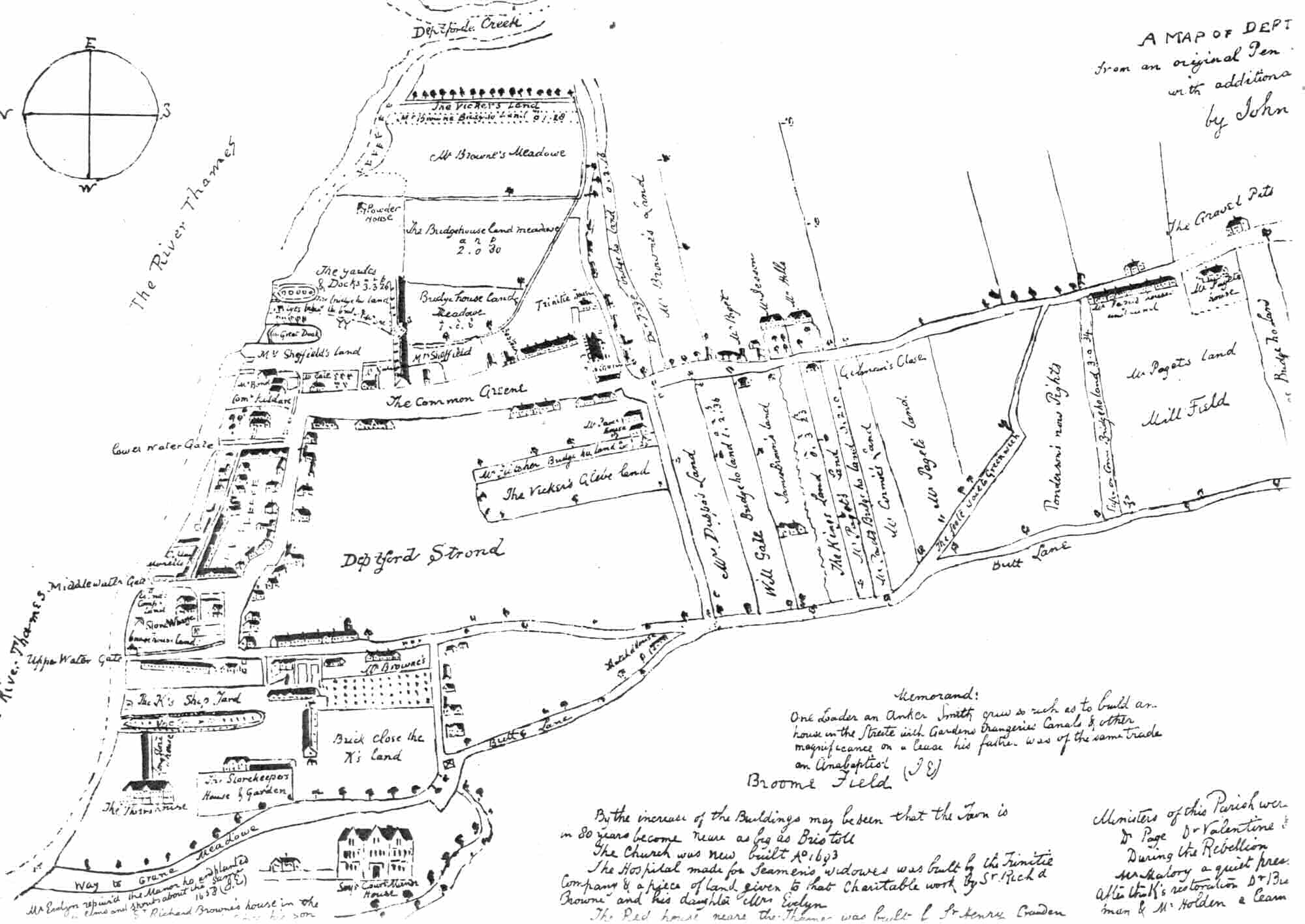 |
| Map of Deptford, 1623, with John Evelyn's notes, late C17th |
James
was a Thames waterman, and lived in Grove Street, Deptford – then
part of Kent, but now definitely in London. His father and he had
both been born in that street, perhaps in the same house. So I
thought it might be interesting to look at this small part of
Deptford
through
maps.
Deptford
is an interesting place from a worldwide perspective, too. In the
Deptford dockyards
ships were built and fitted up to sail to North America, Australia
and many other far-off places.
It was
from the wet dock in Deptford that Captain Cook set off in 1768 on
board the Endeavour to ‘discover’ Australia. Convict hulks
(prison ships) were moored in the Thames off Deptford. It was at
Deptford that the prison reformer, Elizabeth Fry, waved goodbye to
the Maria, a ship full of women convicts who she had helped.
And two of Australia’s earliest convicts of African descent, Billy Blue and John Caesar, lived in Deptford before they, too, were
transported to New South Wales.
 |
| Grove St, Deptford http://www.openstreetmap.org/copyright |
I
started my time-travelling with a map of modern London, because it’s
easier to search. Of course, some streets have been re-named and
others no longer exist, but I was lucky with Grove St. There it was,
a longish street going almost north to south, close to the Thames. I
wondered where James and his family might have lived. Had it always
been this shape and length? Were there any old houses left?
A
quick virtual trip via Google Street View squashed my dreams. Two
Victorian pubs, a car breaker’s yard and a lot of post-war housing.
I wasn't really surprised. I hadn’t expected much to be there, thanks to the Blitz, which targeted London’s docks with great dedication . To give you some idea, have a look at this map, from the excellent Bomb Sight project. Some 650 people were killed in crowded Deptford during the Second World War, including 168 in Britain’s worst single V2 rocket attack on 25 December, 1944. Also killed that year were 13 US naval officers and ratings at an amphibious base supporting the D-Day landings. Such was the war in London’s East End.
I wasn't really surprised. I hadn’t expected much to be there, thanks to the Blitz, which targeted London’s docks with great dedication . To give you some idea, have a look at this map, from the excellent Bomb Sight project. Some 650 people were killed in crowded Deptford during the Second World War, including 168 in Britain’s worst single V2 rocket attack on 25 December, 1944. Also killed that year were 13 US naval officers and ratings at an amphibious base supporting the D-Day landings. Such was the war in London’s East End.
It was time to look at old maps. My great-great
grandfather, James the till-nicking waterman, was born in 1815 and
convicted 20 years later. I wanted to find Grove St as it was in his
lifetime.
 |
| Grove St in 1827. Website © Mark Annand |
Luckily, there is one. Greenwood's 1827 map, which can be seen online at the brilliant Motco and also at Bath Spa University's site.
So here it is - Grove St when my 2x great grandfather lived there. It looks very different. In fact I only recognised it because it starts at a T-junction just south of the larger dockyards.
It's much shorter, too. Only the northern part is called Grove St. To the south it's Victualling Office Row and skirts the huge warehouses where ships' stores were stocked, ready for the voyage.
 |
| 1806. Image via http://www.geographicus.com |
And there are open fields to the east side of the street.
It's surprising to see just how much it was still in the countryside. I went to another favourite map to get a better idea of how rural Upper Deptford was.
Mogg's Pocket Map of London was published in 1806. Here's a view of the area just before James was born. It's hard to square that country with the overcrowded slums of 1944.
Mogg's Pocket Map of London was published in 1806. Here's a view of the area just before James was born. It's hard to square that country with the overcrowded slums of 1944.
It doesn't look as if it had changed much even in the years since the 'Evelyn' map, right at the top, was drawn. Incidentally, if you'd like a proper look at that one,try here. And yes, it does look upside down.
 |
| 1861. Thanks to the The East London History Society |
The dockyard closed in 1869. Sailing ships were superceded by steam, the same steam which drove the other new, fast form of transport - the train.
And with the docks no longer employing people, Deptford lost its purpose and began to slide into
poverty, and the grand shipbuilders' houses became overcrowded. There were hard times on the way.
Irritatingly, I haven't found any maps from the middle of the century which are detailed enough to show buildings apart from Cross's.
 |
| Charles Booth Online Archive http://booth.lse.ac.uk |
Booth based his classification of Londoners' economic status on visiting each area and talking to local people as well as looking around.
This snippet of his map shows how Upper Deptford was then, with better-off streets (in red or pink) to the south-west, poverty (dark blue) in the south-east and Grove St (a muddy-looking purple) described as 'Mixed. Some comfortable, others poor.'
You'll see that Grove St is now the same length as it is today, stretching all the way from the Wet Dock down to Evelyn St, where the red shading begins. It's built up along its entire length. And there are terraces of houses where the fields had been.
I've learned a lot writing this blog post, and I've enjoyed it, too. I'd add a lot of links, but this post is long enough anyway. So I'll be coming back to old maps on my own genealogy blog, A Rebel Hand, before too long.
And I'd love to hear what old maps you like, and if they've helped you in your genealogy journeys.
Unfortunately I am unable to respond to comments at the moment. I have attempted to credit all illustrations correctly and to use only images which are out of copyright when possible. If you would like to make any amendments, please email me and I will correct them.

