Showing posts with label historic maps. Show all posts

Friday, 22 April 2016

Lost in 1939 - The Misleading Map

When Findmypast launched the 1939 Register, Infographic maps which pin-point the place of residence were heralded as a valuable extra.  My grandparent's household at 30 Manor Road, Birmingham is pinned like this:
1939 Regsiter location map for 30 Manor Road, Birmingham

See the problem? The pin is in Sutton Coldfield, not Birmingham.

Mapping locations is a revealing technique for family and local history when the source contains spatial information.  The 1939 Register contains 3 pieces of location information for each household:
  1. Borough or district.  Counties were divided into four  types of units, County borough (C.B), Municipal Borough (M.B.), Urban district (U.D.) and Rural district (R.D.).  These units are listed in Understanding 1939 Registration Districts.
  2. Enumeration district.  Boroughs and districts were divided into manageable areas for an enumerator to cover.  They are denoted by the E.D. letter code.  The One Place Studies blog published a helpful explanation of the 1939 enumeration districts and provide a list of these administrative units.
  3. Street address. No explanation needed.
Extract of 1939 Register with location information highlighted

My grandparents lived in Stechford which was in the Birmingham County Borough.  A Vision of Britain through Time is a comprehensive resource for jurisdictions in the UK.  Sutton Coldfield was a Municipal Borough until it was merged with Birmingham in the 1974 re-organisation of local government.  In 1939 the boundary of Birmingham County Borough was:
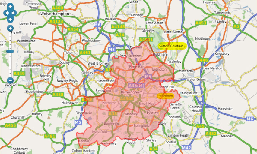
Birmingham County Borough, with Sutton Coldfield and Stechford highlighted.  Source: A Vision of Britain.

Sadly smaller units like enumeration district QBEZ are not mapped in A Vision of Britain.  Census enumerators books included a place to enter as description of the area covered, but I don't know if 1939 Register booklets did.  Browsing the 23 images in the district reveals that only pages with personal entries have been published, so the context of the enumerator's work is missing.  From the street addresses, it is possible to gain an insight of the area covered.  Seven roads are named: Lyndon Road, Manor Road, Church Road, Station Road, Rosemary Road, and Yardley Fields Road.

All of the roads in enumeration district QBEZ are incorrectly scattered around Sutton Coldfield on Findmypast's maps.  Here is a Google maps comparison of the real locations and Findmypast's locations:
Enumeration district QBEZ.  Roads denoted by lines are actual locations, those denoted by pins are the 1939 Regsiter locations
 
A road is a linear feature, so is better represented by a line than a point.  Road names like Manor, Station, and Church are common. There are even several Lyndon Roads. These roads have been matched with other roads of the same name.  Matching locations using a gazetteer, a geographical index of place names with co-ordinates or grid references, is fraught with difficulty.  Red House, Rosemary and Yardley Fields roads were all pinned to the same spot as the incorrect Manor Road pin.  It is likely that the more uncommon road names could not be matched, so were assigned to a pin thought to be in the enumeration district. 

Findmypast's pins mislead even when correctly placed.  A point or pin suggests accuracy, so one might expect it to identify a house.  An jurisdictional area like an enumeration district or borough is best represented by a polygon, a shape which denotes the boundary of the feature.

Mapping technology is now widely and freely available.  Findmypast used open source mapping software, Leaflet, to present the maps, delivering a smooth user experience.  That was a smart move.  Using the digitised historical maps from the National Library of Scotland and modern OpenStreetMap was another smart move.  All of that came free.

It is clear that the jurisdictional boundaries from A Vision of Britain weren't used.  Adding that data layer could have unleashed the power of spatial queries, eliminating the type of errors discussed here.  The data seems to be available only for academic use, but the website was built over a decade ago, so would greatly benefit from serious investment.  Investing in the development and expansion of A Vision of Britain would be, well visionary.

Tuesday, 22 September 2015

Collaborative Geo-referencing of Maps

Last month Pat Richley-Erickson's contribution Google Earth for Genealogists brought our attention to overlays of historical maps available on Google Earth. The historical maps were georeferenced  to create overlays that are in the correct place. Once maps have been georeferenced, they can be compared and integrated with other mapped data, which can lead to better understanding of their contents. The best way to understand the process and its limitations is to try it for yourself.

The National Library of Scotland, British Library, David Rumsey Map Collection and other institutions use the online Georeferencer application for their collaborative map georeferencing projects. Due to differences in scale, projection and accuracy the historical map will not match a modern reference map. Imagine the historical map was printed on a rubber sheet, which you can stretch and pin it down to the modern map at known points. By the magic of mapping technology, Georeferencer does all the calculations behind the transformation.

An example from the British Library is a map of the parish of Thompson, a village in rural Norfolk, England a few miles from my home. It was published in a book about the history of Thompson published in 1892, but it was redrawn from an earlier map dated to around 1725 which shows open fields, a farming system from medieval times.

Having selected this map and opened it in the British Library georeferencer, my first job was to locate Thompson on the modern map and zoom in so I could see features marked on both maps. I started with the church, a good bet in rural England where churches may stand for centuries. Other features required some interpretation and local knowledge. Rivers and roads may change course so are not good candidates for control points. In this case the parish boundary has remained the same so points where it intersects other features or sharply changes direction are helpful. I needed to use several of the supplied reference maps and satellite images to find enough features for 10 control points.

control points
Control points on the Thompson map on the left match reference maps and satellite image on the right.

The visualize tab gives 2D, 3D and side by side viewing options. The 2D option lays the historical map over Google maps, and the slider changes the transparency of the historical layer. The 3D option opens Google Earth in a small window, so you would do better to click on the 'Open KML in Google Earth' link. Notice many of the field boundaries follow older features. I had not realised that Thompson Water is a modern feature!

Overlay of Thompson map in Google Earth

A harder example, from The National Library of Scotland, is a map of Islay, an island off the west coast of Scotland, dated 1654. Many of the place names on the historical do not appear reference maps. Variant spellings of place names add to the challenge. Notice that the historical map appears distorted compared to the modern map.

Comparison of Islay map on left with modern map right, with control points

Eventually I managed to locate 36 control points. In the process I gained an insight that I would never have realised otherwise. This map was drawn from the perspective of someone at sea. The relative positions of settlements as seen from the sea is emphasized. At the time this map was made, sea travel predominated. Geographic accuracy is compromised and, even with a lot of correction, only achieves a poor match to the modern map.

Transformations of Islay map, increasing correction from left to right.  Left:affine, centre:polynomial, right: TPS
Transformations of Islay map, increasing correction from left to right.  Left:affine, centre:polynomial, right: TPS
Is the 1654 map of Islay a bad map? It was produced before projections had been invented, so it is not really fair to expect it to conform to modern thinking.

All maps lie because representing the earth's surface on a flat piece of paper always requires compromise. Although we think of the earth as a sphere, in reality it is flattened at the poles and very lumpy. The mathematical transformation of geographic co-ordinates onto a flat plane is called a projection.  Projections preserve one of area, distance or direction while distorting the other two. The most familiar Mercator projection preserves direction, important for nautical navigation, but distorts the area of objects near the poles.

Ready to explore for yourself? Go and have fun discovering things were not as you thought.